Ing. Ladislav Vizi
Department of geology and mineralogy
F BERG - Technical University of Košice
Pk. Komenského 15
043 86 Košice
E - mail: Ladislav.Vizi@tuke.sk
Doc. Ing. Gejza M. Timčák, PhD.
Departmennt of geopropagation
F BERG - Technical University of Košice
Pk. Komenského 9
043 86 Košice
E - mail: Gejza.Timčák@tuke.sk
Ing. Peter Blišťan, PhD.
Department of geology and mineralogy
F BERG - Technical University of Košice
Pk. Komenského 15
043 86 Košice
E - mail: Peter.Blišťan@tuke.sk
The Kisovce-Svabovce deposit is an Mn orebody situated in the East Slovakian region (near Poprad). It is at present abandoned. The mining operations started at the 2nd half of the 19th Century and they were terminated in 1971 due to low market demand and sub-profitable selling price of the ore. Mineralogically the ore minerals are manganochrosite and manganite. A renewed interest in the deposit has led to the re-evaluation of the data on the deposit.
The original and geostatistically estimated data were integrated into a GIS implemented in the ArcView environment. The paper gives the GIS project details.
Mangánové ložisko Kišovce-Švábovce sa nachádza vo Východoslovenskom kraji v blízkosti mesta Poprad. V súčasnosti sa toto ložisko neťaží a je opustené. ťažba tohto ložiska sa začala v druhej polovici19-tého storočia. Z dôvodu zvyšovaniu nákladov na ťažbu a následného poklesu ťažby rudybola ťažba v roku 1971 zastavená. Mineralogicky je mangánová ruda tvorená manganochrozitom a samotným mangánom. Opätovný záujem o ložisko Kišovce-Švábovce viedlo k prehodnoteniu ložiskových údajov.
Prieskumné ako aj geoštatisticky odhadované dáta boli integrované do GIS v prostredí ArcView.
The Kisovce-Svabovce deposit is a horizontally placed Mn orebody situated in the East Slovakian region (near Poprad), where detailed geological survey was carried out. It is at present abandoned. The mining operations started at the 2nd half of the 19th Century and they were terminated in 1971 due to low market demand and sub-profitable selling price of the ore. Mineralogically the ore minerals are manganochrosite and manganite. The paper geostatistically model the available tonnage.
The deposit of sedimentary origin is horizontally divided into the following parts: Primovce, Švabovce, Kišovce and the part extending to the Levoča Mts. It consists of 3 vertically separated parts. The paper shows the grade/tonnage curves for the available deposits.
The recent renewed interest in the mining of this deposit had led to a geostatistical modelling of the deposit. The paper deals with developing a 2D model of the distribution of the assessed chemical data and a geostatistical estimate of the ore reserves, using the ISATIS software. Further, a geostatistical analysis of the chemical data and of the orebody thickness data was carried out. The simulation of the spatial distribution of chemical constituents and of orebody thickness was also performed.
The work was enabled by the availability of old and new borehole data (chemical data - Mn, Fe, SiO2, P, from about 140 irregularly spaced vertical boreholes) from the area of extension of the deposit.
The original and geostatistically estimated data were integrated into a GIS implemented in the ArcView environment.
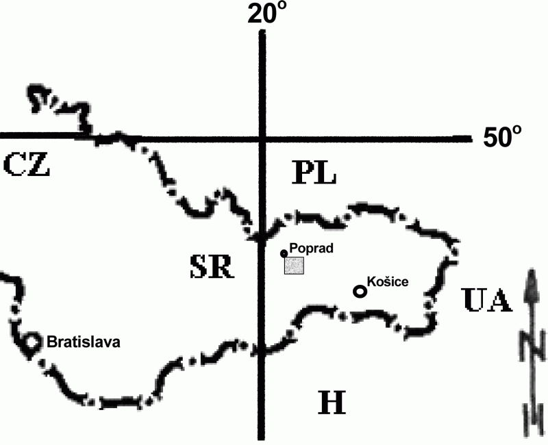
The region with manganese ore mineralization is situated in the basin under the High Tatra Mts and extends to SE from the city of Poprad (Fig. 1).
Fig. 1 Geographical position of the area under study
The deposits that were investigated are situated in the area of Švábovce, Kišovce and Hozelec. At the end of the 19th Century the Mn ores were mined in the near surface portions of the deposit in the cadastre of Kišovce. At the beginning of the 20th Century these parts of the deposits were exhausted and thus subsurface mining started. During the WW 1st the mining was extended to the vicinity of Švábovce. Documentation of the mined tonnages exist only since after the WW 2nd. Up to 1956 the mining was intensive, after that date the demand for Mn ore fell. It was caused mainly by the lower demand for Mn during steel production as the processed ore contained sufficient amount of Mn. Further, the import of Mn ores depressed the local mining. The lowering of mined tonnages in the period of 1956-1961 has resulted in a cost increase. Later, as the selling price ceased to cover the production price, the mining activities stopped. Thus in 1971 mines at Kišovce and Švábovce were decommissioned.
Recently, a new interest was generated in the area of abandoned Mn ore deposits and this work is a part of a feasibility study.
The geological setting is given in Vizi, Timčák, Hosa (2002).
The deposits are horizontally placed and their extent in E-W direction is considerable. The upper deposits of Mn ore (the "upper" and "main" deposit) are regularly developed; the lower one has an irregular development.
The studied deposit has an average thickness of 0.05-0.4m and has an 8-11% Mn content (not mineable).
The main deposit has an outcrop in the southern part of the studied region and there is an another outcrop further to the south, after the Kišovce fault. The upper end of the main deposits has a vertical offset of 40 to 80m.
The lower deposit is 40 to 50m below the main deposit. Its thickness is only 0.2m, spatially is incongruent and was penetrated only by some of the exploratory drill holes.
The deposit is situated in the SE part of Švábovce and covers 0,4km2. Its outcrop limits the southern rim. The western part of the deposit is limited by the Švábovce deposit, the eastern part by a fault parallel with the Prímovce fault that is called the Eastern fault and its extent to the north is limited by the Kišovce fault. The deposit is nearly horizontal and has a dip of 10-15o to NE. The main deposit is in a 22-60m depth.
It consists of two mine field - the Švábovce (SE part) and the Intermediate (N part) ones that are tectonically separated by the Kišovce fault. The offset of the Švábovce deposit is by about 40m. The eastern border is defined by the Prímovce fault, the northern one by the Kišovce fault, the southern border is limited by the outcrop of the deposit and the western one is given by the Hozelec fault.
The intermediate area has the form of a trapezoid and is tectonically limited by the Švábovce (S) and by the Kišovce (N) faults. Its western limits are 400m long, the eastern ones are 80m long. The main deposit in the intermediate area is situated in a depth of 40-50m, in the western part is in the depth of 150m.
The Švábovce minefield extends to south from the Švábovce fault.
On the SW it is limited by the Kišovce fault and on the SE by the eastern deposit. At the north it is limited by the Northern fault. Its western border is formed by the Hozelec fault.
This deposit is formed by the continuation of the Kišovce deposit to the E, N and W. It is formed also by the W continuation of the Švábovce deposit.
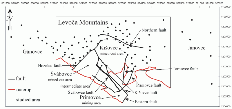
Fig. 2 The map of tectonic features, mine fields and of the exploratory drill holes
The study deals with the geostatistical model of the Kišovce-Švábovce Mn ore deposit and its Levoča Mts. part. The study was done for assessing the remaining tonnage of the deposit and for the modelling of the geometry of the parts of the main deposit above cut-off level.
For the study we had at our disposal the records of an irregular grid of boreholes localised in the studied part of the Levoča Mts (Fig. 2). Apart from that we could also use a 1:5 000 and 1:10 000 (Antonická et. al., 1999) geological map that contained the course of the main geological faults as well as the outcrops of the deposit and the elevation isolines of the terrain. The records were used for developing a drillhole database.
The study is divided into two parts:
1. The geostatistical model of the deposit and grade/tonnage calculation,
2. The transfer of the geostatistical modelling results to a GIS.
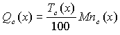
Drillhole database for geostatistical estimation of the Mn accumulation contains the XYZ coordinates of the drillholes and the variable containing the weighted Mn content calculated according to the equation (Report 1962):
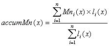 , [1]
, [1]
where Mn i(x) is the Mn (%) content at position x and li(x) is the length of the analysed core at position x.
Tab. 1 shows the basic descriptive statistics of the studied Mn accumulation. The experimental values of the Mn content were used for the construction of the experimental variogram for lag values of 120m with 13 lags for the four basic directions within the studied area. As the directional variograms did not exhibit anisotropy, a theoretical model was fit to the experimental multidirectional variogram. That contained one basic structure without nugget effect with a range of 1500m and a sill value of 5.5%2 (Fig. 3). The sill was only slightly lower than the experimental one (5.87). The average of the standardised deviations calculated on a cross-validation basis was 0.03 (i.e. close to zero) and the dispersion of these deviations was 0.99 (i.e. close to 1).
Number of specimens | Minimum [%] | Maximum [%] | Average [%] | Standard deviation | Dispersion | Skewness | Kurtosis |
67 | 8,2 | 19,27 | 15,05 | 2,42 | 5,87 | -0,24 | 2,75 |
Tab. 1 Basic statistical parameters of the experimental values of Mn content
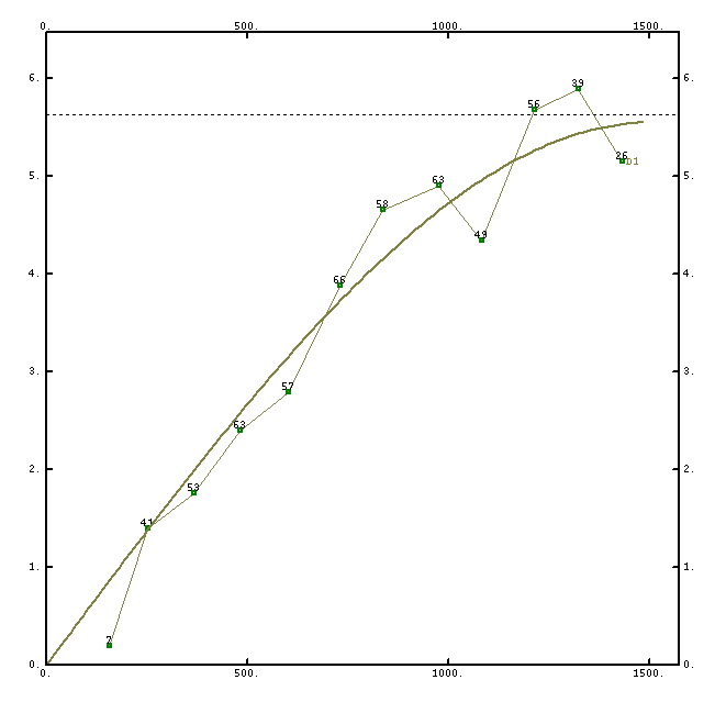
Fig. 3 Experimental variogram with the fitted theoretical model
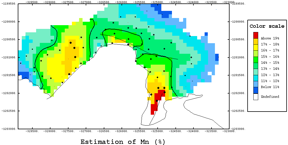
On the basis of the described theoretical variogram model of the Mn accumulation, the average values of the Mn content were estimated for 100x100m panels, using a moving neighbourhood with four angular sectors with a minimum of 3 values for the sector with a 750m radius. Fig.4 shows the resulting block estimation together with a post-plot of the experimental values of the Mn accumulation as well as the course of the faults and outcrops. The shown isolines represent the contour of the Mn content over 15% that is the condition for feasibility at the time when the deposits were mined. Tab. 2. shows the calculated statistical parameters of the estimation of Mn content as well as the estimation errors.
| No. of panels | Minimum | Maximum | Average | Standard deviation | Dispersion | Skewness | Kurtosis |
Estimated value | 846 | 10,55 | 19,22 | 14,54 | 2,105 | 4,43 | 0,29 | 2,22 |
Estimation errors | 846 | 0,33 | 2,02 | 1,01 | 0,36 | 0,13 | 0,49 | 2,64 |
Tab. 2 Basic statistical values of the estimated Mn content and of the estimation errors
On the map of the Mn grade (Fig. 4) we can see that the Northern fault has no effect on the Mn distribution. The Primovce fault separates the area where no data were available.
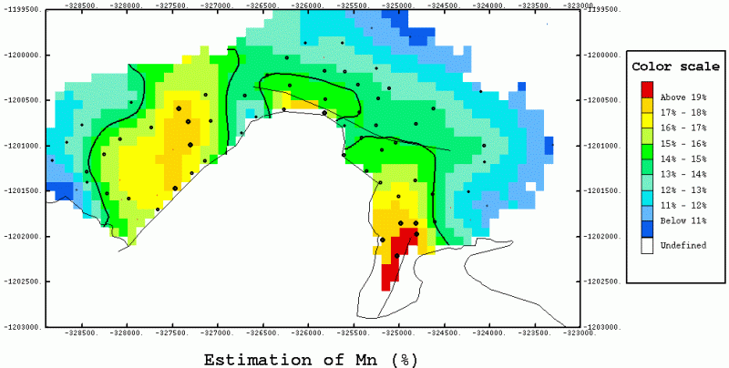
Fig. 4 Map of the Mn grade estimated by ordinary kriging (view in the full resolution)
For the estimation of the seam thickness a different strategy was selected. The seam thickness was estimated on the basis of multivariate geostatistical analysis of the top and bottom of layer elevations using the expression (Rivoirard, 1994)
![]() , [2]
, [2]
where t(x) is the seam thickness, Z(x) is the elevation a the indexes ToL denote top of the Layer and BoL the bottom of Layer. The CK index represents co-kriging.
The reasons for selecting this procedure was the following:
1. Very low seam thickness (tens of centimetres to 80 cm - see Tab. 3)
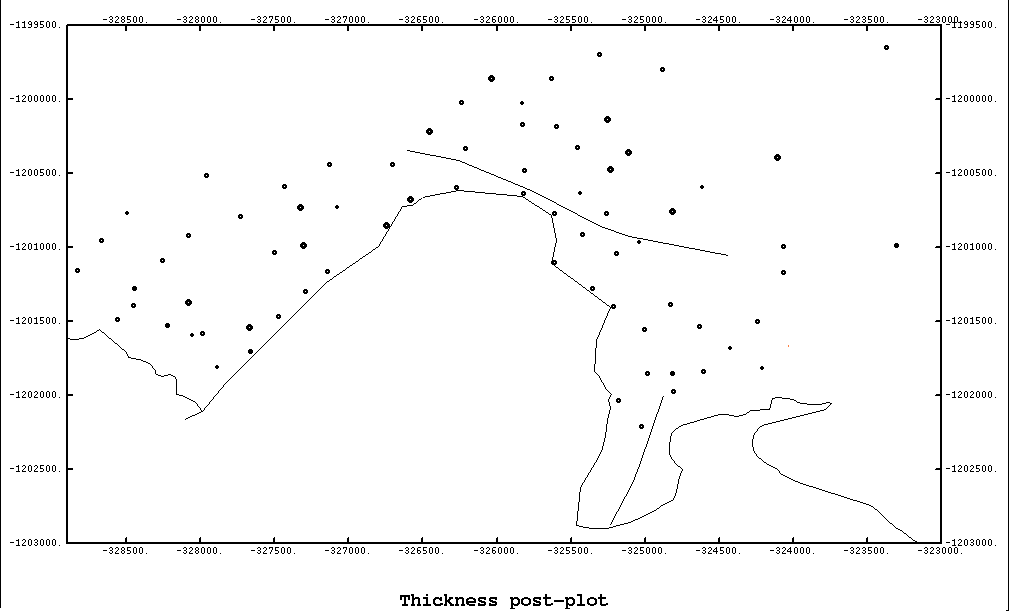
2. Too high thickness variability within too short distances that are due to the geological processes of sedimentation (Fig. 5) that caused an instability of the experimental variogram
3. The need to model the seam elevation for the depicting the seam course within the GIS
4. High correlation between the top and bottom of the seam (0.9997 - see Fig. 6).
No. of samples | Minimum [m] | Maximum [m] | Average [m] | Standard deviation | Dispersion | Skewness | Kurtosis |
72 | 0,1 | 0,8 | 0,38 | 0,15 | 0,02 | 0,48 | 3,74 |
Tab. 3 Basic statistics of the experimental ore seam values
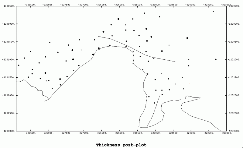
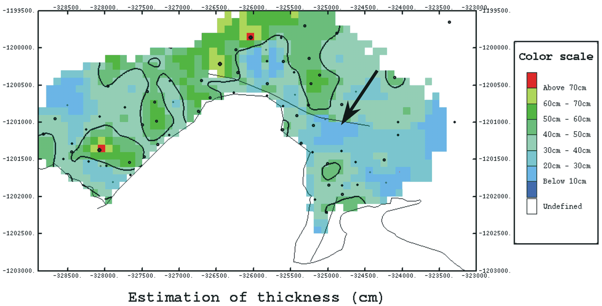
Fig. 5 Proportional post-plot of the Mn ore seam thickness (view in the full resolution)
Due the low seam thickness it was necessary to convert the seam elevation values from metres to centimetres, so that the resulting thickness will also be in centimetres.
On the basis of the experimental elevation values the experimental variograms and cross-variograms were calculated that showed no directional anisotropy. Fig. 6 shows these variograms as well as the cross-variograms with the fitted theoretical model consisting of two basic spherical structures without nugget effect and range of 350m and of 1150m. The average standardized deviations calculated by cross-validation was 0.01; the dispersion was 0.81.
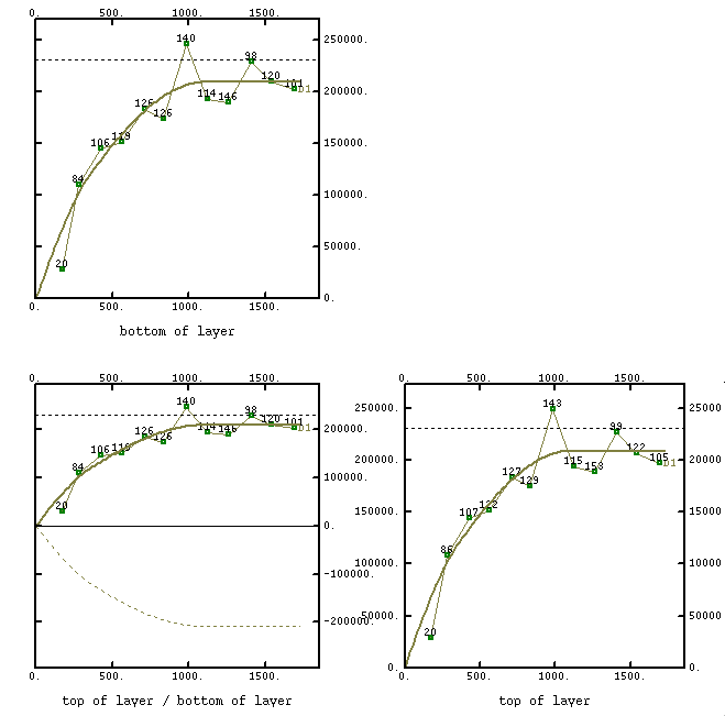
Fig. 6 Experimantal and theoretical variograms and cross-variograms of the top and bottom elevations of the Mn ore seam.
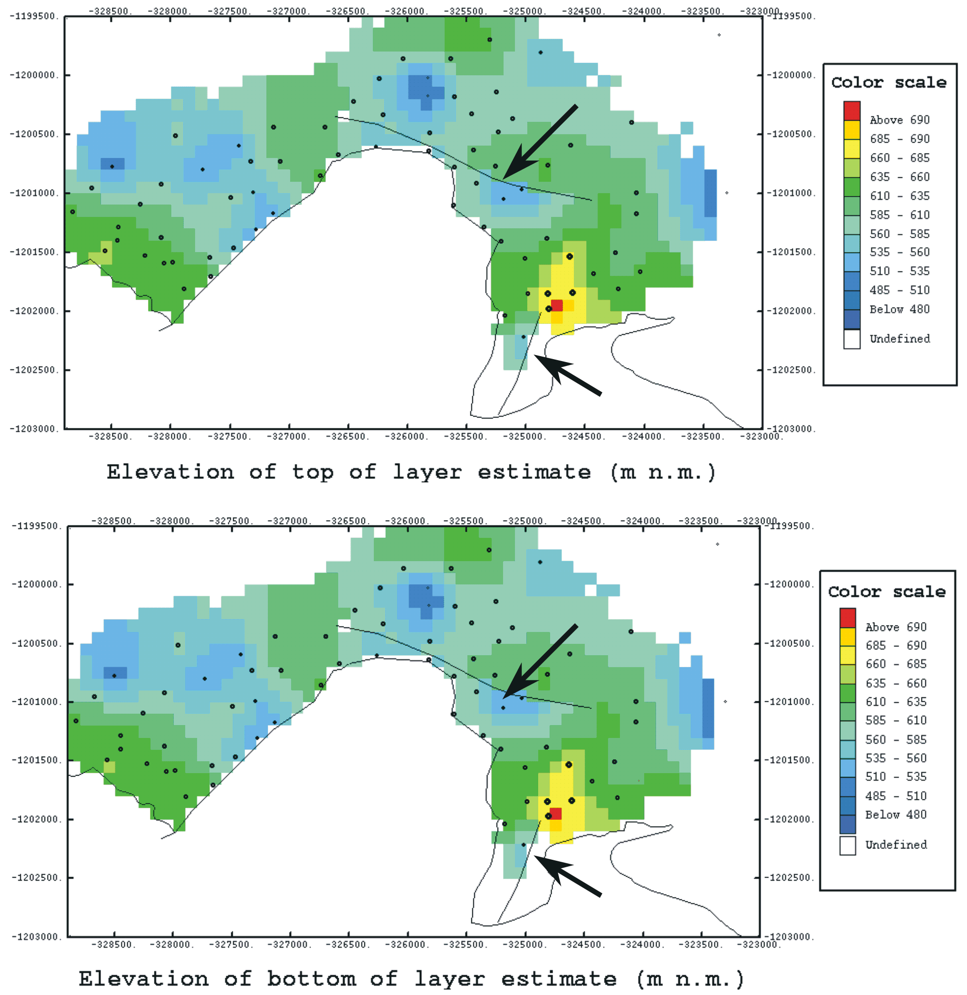
On the basis of the described theoretical model the multivariate estimation of the top and bottom elevations for blocks of 100x100m. Fig. 7 shows the resulting estimations of elevations that show a high correlation coefficient value similar to that of the experimental data.
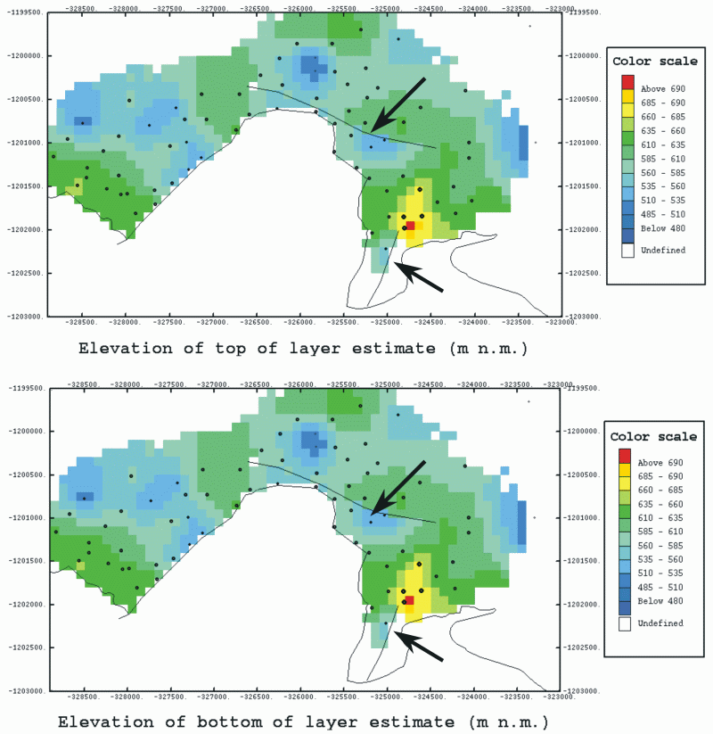
Fig. 7 The effect of faults on the top and bottom elevation estimates (view in the full resolution)
Fig. 8 shows the estimation of seam thickness (in cm) together with the porportional post-plot of experimental thickness data calculated according to equation [2]. The isoline shown represents a 40cm thickness contour. The 40 cm value was the cut-off thickness at the time of mining of the deposit.
Tab. 4 shows the calculated statistical parameters of the estimation of Mn deposit thickness.
No. of panels | Minimum [cm] | Maximum [cm] | Average [cm] | Standard deviation | Dispersion | Skewness | Kurtosis |
846 | 10,27 | 73,95 | 36,06 | 11,61 | 134,82 | 0,19 | 2,92 |
Tab. 4 Basic statistical values of the estimated Mn deposit thickness
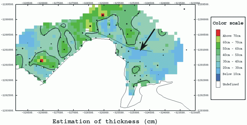
Fig.8 The effect of the Northern fault on seam thickness (view in the full resolution)
The grade/tonnage was calculated on the basis of the following equations:
![]() , [3]
, [3]
 , [4]
, [4]
where:
Qc(x) is the grade of Mn ore [t],
P is the area of the estimated panel that equals to 100x100m = 10000m2,
t(x) is the estimated seam thickness [m],![]() is the specific gravity of Mn - 2,93 [t/m3],
is the specific gravity of Mn - 2,93 [t/m3],
Tc(x) is the total tonnage of Mn ore [t],
Mnc(x) is the estimate of the Mn content.
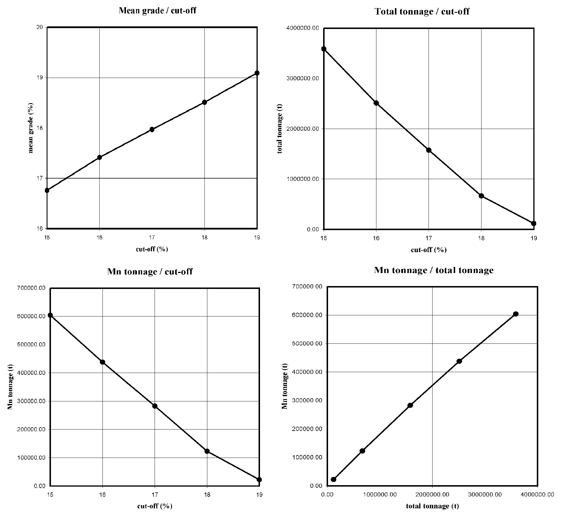
Tab. 5 contains the calculated average Mn content, of the tonnage and grade for a 15%, 16%, 17%, 18% and 19% cut-off level. Fig. 9 shows the grade/tonnage curves.
cut-off | AVG | min [%] | max [%] | No. | area [m2] | volume [m3] | total tonnage [t] | grade [t] | % of tons | % of grade |
0 | 14.57 | 10.11 | 19.22 | 846.00 | 8710000 | 3050594 | 8938240.42 | 1310300.92 | 100.00 | 100.00 |
15 | 16.76 | 15.01 | 19.22 | 334.00 | 3340000 | 1224322 | 3587263.46 | 604413.65 | 40.13 | 46.13 |
16 | 17.42 | 16.00 | 19.22 | 222.00 | 2220000 | 857272 | 2511806.96 | 438162.63 | 28.10 | 33.44 |
17 | 17.97 | 17.05 | 19.22 | 133.00 | 1330000 | 538186 | 1576884.98 | 282953.34 | 17.64 | 21.59 |
18 | 18.51 | 18.00 | 19.22 | 59.00 | 590000 | 227075 | 665329.75 | 122993.50 | 7.44 | 9.39 |
19 | 19.09 | 19.00 | 19.22 | 12.00 | 120000 | 39976 | 117129.68 | 22368.52 | 1.31 | 1.71 |
Tab. 5 The grade/tonnage curve values
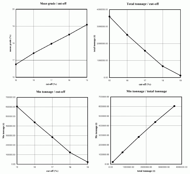
Fig. 9 Grade/Tonnage curves (view in the full resolution)
The original and estimated data on the Mn deposit were incorporated into a GIS project. The GIS project was implemented in ArcView 3.2. environment. Below a brief description of the GIS is given.
A 1:10 000 map of the surface (Antonická et al. 1999) was vectorised and warped in MicroStation PC environment. The resulting digital map was used to display - apart from the basic topographical data - the drillhole sites, drillhole course, the deposit contours, thickness grades and Mn content grades.
The XYZ coordinates of the drillholes, of the top and bottom elevations of intersections with the deposit seams and cumulative Mn content data (for the whole intersection length) were included into the database.
For the blocks, the estimates of XYZ coordinates of tops and bottoms of the ore seam, estimated seam thickness, block volume, block tonnage for different cut-offs and Mn content of blocks for different cut-offs were also included into the database.
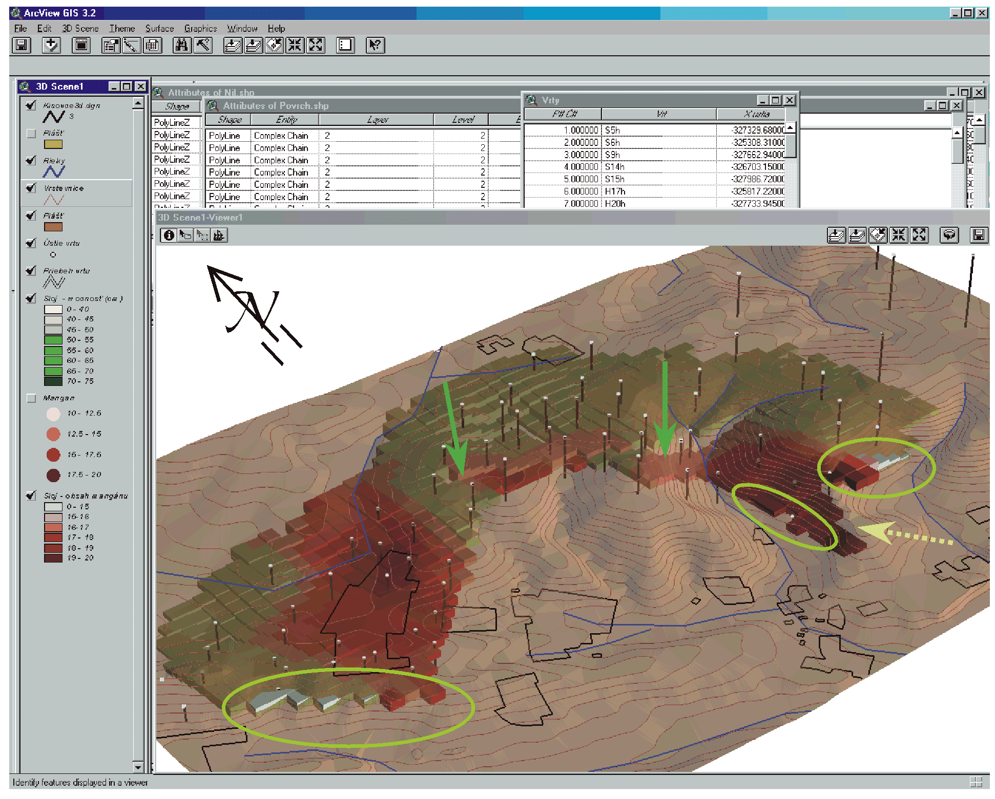
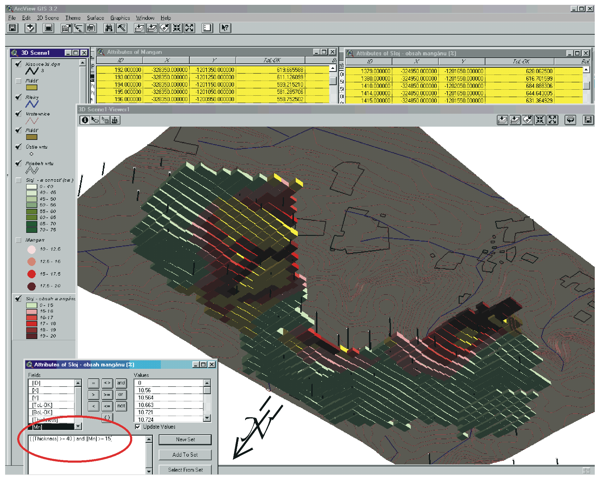
The developed GIS project enabled the visual modelling of the deposit and he visual modelling of search results for various selection criteria (e.g. for seam thickness greater or equal to 0.4m and Mn content greater or equal to 15% - see Fig. 11). Fig. 10 shows a top view of the distribution of various ore grades in the deposit.
The paper presents a part of the results of geostatistical modelling of the Kišovce-Švábovce Mn ore deposit and gives an outline of the GIS project that was aimed at enabling spatial display and modelling of the deposit. Presently further work is being carried out in processing the available archive data on the deposit.
The deposit - if we consider the present day mining and processing technologies - does not seem to be mineable.
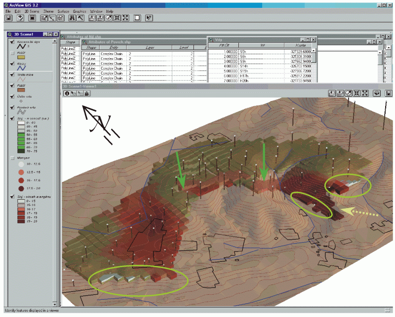
Fig. 10. A top up view of the GIS data: In the upper part a portion of the database table is shown, below it, the topographical situation and the deposit layout and ore grades are shown. Green arrows point to the Northern fault, the yellow, dotted arrow point to the Prímovce fault. Ellipses encircle the deposit outcrops. The vertical scale of the deposit is enhanced to enable better visibility. (view in the full resolution)
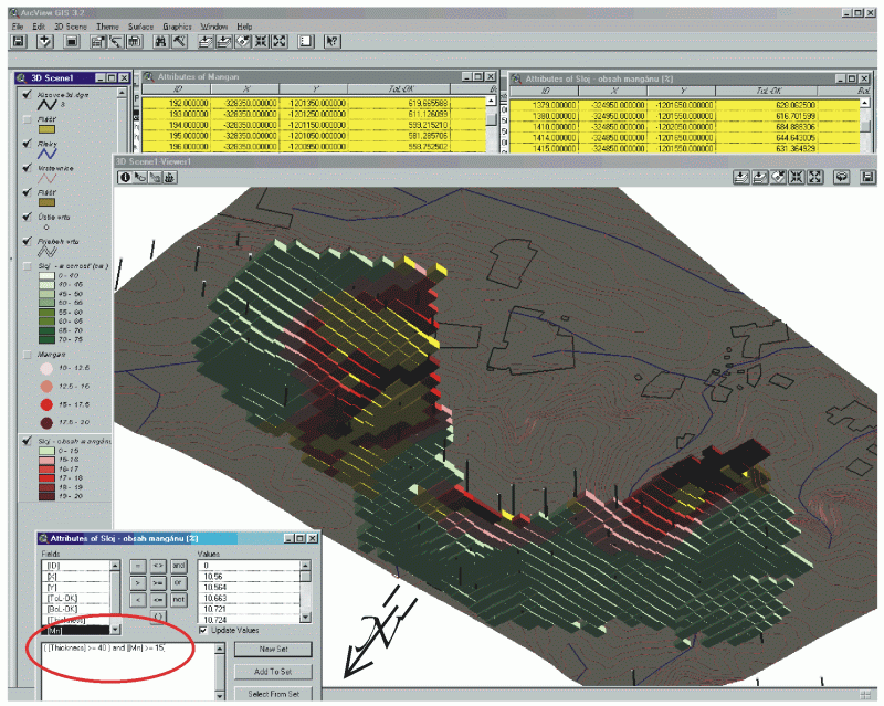
Fig. 11. A bottom up view of the deposit. See the examples of search results for those parts of the deposit that satisfy the condition of Mn>15% and seam thickness >40cm (cf. with the yellow selection in the table) (view in the full resolution)